The Battle of Brooklyn
By Morgen Fleisig on Day 3, March 2010
So I actually ended up spending yesterday researching the history of The Battle of Brooklyn–also known as The Battle of Long Island–for a game Julio Terra and are working on for Come Out and Play.
The game would consist of two teams defending and conquering territory in the current landscape with reference to the landscape that existed at the time of battle.
Ideally, historically important destinations will be geotagged, and players can see where they are on period maps, relating it obviously to where they are in the contemporary city. The “Redcoats” will be given specific objectives to capture, while the “Revolutionaries” will be given defensive positions, and can send out expeditionary forces to prevent capture.
The capture and defend mechanism is at the moment envisioned with cameras. The Redcoats photograph predetermined locations and icons, and email them back to headquarters, while the Revolutionaries try to defend those positions by photographing the Redcoats first. The game may or may not end with a variant of Capture the Flag at Stone House, the likely game headquarters, and site of one of the final critical skirmishes of that battle.
Each team’s status along the way would be updated with reference to how the actual battle played out, so that players have the opportunity to learn about the historical events that occurred in the locations the game is taking place, and develop a deeper appreciation for Brooklyn’s past and relevance to early days of the Revolution.
The critical locations stretch from Gravesend Bay at the southern end of Red Hook, to the Cemetery of the Evergreens, and west to Brooklyn Heights, as can be seen from “Howe’s Map” of October 1776:
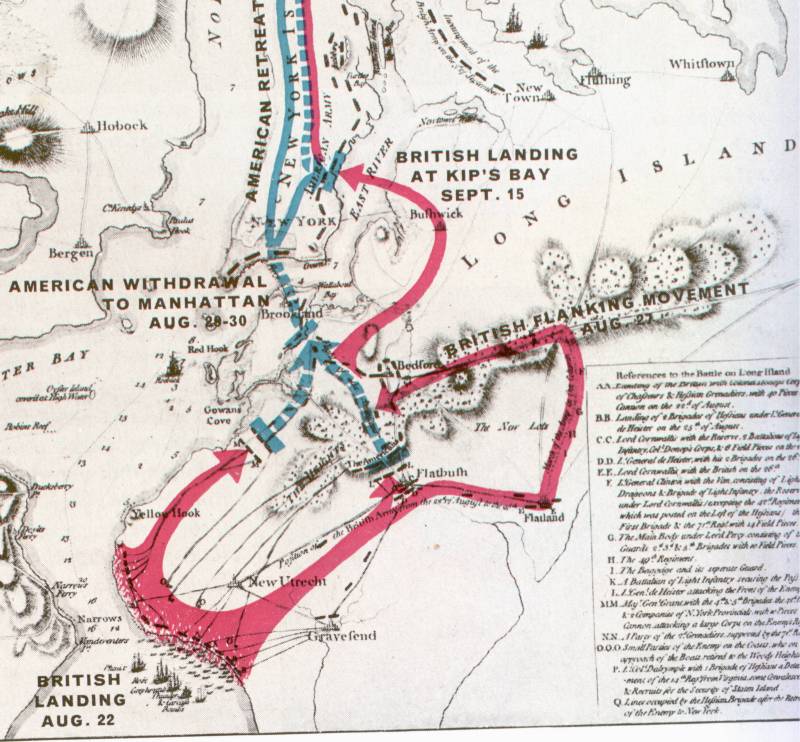
Credit: Brooklyn On Line
The point to the British seizing Brooklyn and New York was to wrest control of the Hudson River from the Americans and separate New England from the remainder of the Continental United States.
Critical locations and dates [Credit:Â Brooklyn On Line and NY Freedom]:
View The Battle of Brooklyn in a larger map
March 16th, 2010

Leave a Comment
Trackback this post | Subscribe to the comments via RSS Feed